| Nicholas King Northwest 1803 Map
 Nicholas King Northwest 1803 Map Nicholas King Northwest 1803 Map
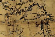
This map of the Northwest was put together by cartographer Nicholas King at Albert Gallatin's direction in 1803. It combined elements from maps drawn by Aaron Arrowsmith, Andrew Ellicott, James Cook, George Vancouver, and others. It represented the best British knowledge of the American West. Though the information is sketchy and river courses speculative, King’s map shows the limit of the Missouri drainage close to where it actually is. The location, if not expanse, of the Rocky Mountains is also accurate (Allen, 1975). Image courtesy of the Library of Congress, Geography and Map Division.
View also in MrSID format. |


