| MODIS Image of Central Atlantic Seaboard
 MODIS image of Central Atlantic Seaboard MODIS image of Central Atlantic Seaboard
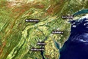
This MODIS true-color image taken in mid-October 2000 shows the central Atlantic seaboard. It is also useful for showing the Appalachian Mountains. Start with Philadelphia on the Atlantic Coastal Plain, east of the Appalachians. Like the other urban areas, it is pale gray. The pale green and yellowish areas south and west of the city and elsewhere in the image are grass or farmland. . The Appalachians run southwest to northeast in the left side of this image. The mountains then curve more toward the east at the Blue Mountains. Blue Ridge and the Blue Mountains mark the first ridge in the Appalachian Mountain range. The dark green areas show green forests whose leaves have yet to change an autumn red or gold. The brown and rust colors are leaves that have changed to their autumn colors. Now that you know what the different colors indicate, you can see how the change in vegetation color enhances the appearance of the Appalachian Mountains.
|


