| Estimated Population Density in 1803
 Estimated Population Density in 1803 Estimated Population Density in 1803
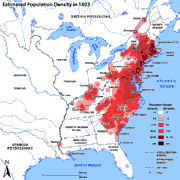
By the start of the 19th century, most of the non-Native population still lived east of the Appalachian Mountains. Philadelphia was centrally located near the coastal part of the United States. Its access to agricultural lands, navigable rivers, and a harbor made Philadelphia the major urban center at this time. The map displays estimated population density for the United States in 1803. The major trade and port cities of Boston, New York, and Philadelphia had the highest density, while the interior mountains and plateaus had the lowest. A small core of population began developing west of the Appalachians in Kentucky and Tennessee. This map does not include population densities for the Spanish-controlled areas of Florida or Texas.
|


