| Andrew Ellicott
When Meriwether Lewis needed to learn celestial observation to help map his journey, President Jefferson knew exactly where Lewis should go—to Andrew Ellicott.
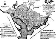 |
| Andrew Ellicott's plan for the city of Washington, DC, completed the first plan started by the French architect, Charles Pierre l'Enfant. Image © 2002 www.clipart.com. |
Ellicott was America's foremost surveyor along with being an accomplished astronomer and mathematician. Raised in Ellicott Mills, MD, the town founded by his father, Ellicott was quite accomplished by the time Lewis visited him at Ellicott's Lancaster, PA, home in April 1803. Ellicott had already conducted several large surveys that established state and territorial boundaries. His work included the boundary between the United States and Spanish possessions in Florida.
Perhaps his most famous work was in 1791 when President Washington asked him to survey the bounds of the District of Columbia. The next year Washington asked him to complete L'Enfant's plan for the city. After his changes were accepted, he eventually resigned from the project in a dispute with the ruling commissioners.
In 1803 he published The Journal of Andrew Ellicott. It mapped the mouth of the Mississippi River and also fixed the position of the mouth of the Missouri River quite accurately. Those maps were used in the map of North America Nicholas King made specifically for the Lewis and Clark expedition. Ellicott was a strong supporter for purchasing Louisiana. That helps explain his enthusiasm toward Lewis, who found Ellicott to be "extreemly friendly and attentive."
Ellicott taught Lewis how to use a sextant, octant, chronometer, and other surveying equipment during Lewis' nearly three-week visit.
< previous | next > | 


