The Rocky Mountains and the River of the West
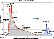 |
This elevation profile of the route Lewis and Clark took shows the incredibly divergent path they followed. |
The Missouri became the recognized water road to the West that extended to the Rocky Mountains. Beyond the mountains was the expected river of the West that led to the Pacific Ocean. But what was the nature of the mountain barrier, and where did the river reach the ocean? The expectation was that the mountains and rivers of the West mirrored the mountains and rivers of the East. That is, one could paddle up the Missouri to the Rockies—which were assumed to consist of a few ridges like the Appalachians—make a short, easy portage through the low passes to the tributaries of the River of the West, and float easily down to the Pacific Ocean. Most maps of the era showed the Rockies as a single ridge of hills with streams of both the eastern and western river systems extending almost to the point of touching each other (for example, Arrowsmith's 1802 map and King's 1803 map).
British explorers provided most of the support for these ideas. The British, after taking over the French possessions in Canada in 1763, took up the search for the passage to India, but along the Saskatchewan River system in central Canada rather than along the Missouri. Consequently, their explorations took them around the north flank of the Louisiana Territory.
Alexander Mackenzie led one of the most successful British explorations. He ascended the Peace River in 1793 through the front range of the Canadian Rockies to the river's source. There he found a short—700 meter—portage over a low, poorly defined ridge to the headwaters of a river flowing toward the Pacific. He followed the river until it became impassible because of rapids and then cut cross-country to the Pacific coast north of Vancouver Island. In his published journals Mackenzie commented that the Rockies continued "with less elevation" to the south of his path. Jefferson and others extrapolated this to mean that nearly 1,000 miles to the south of the Rockies, at the headwaters of the Missouri, would be a low, narrow ridge that would be easy to cross.
The west side of the unknown northwest, the Pacific coast, had been mapped by navigators from several nations, beginning with the Spanish captain, Bruno Heceta, and the English captain, James Cook, in the mid 1770s. In 1775 Heceta viewed, but could not enter, the mouth of a great bay near 46 degrees north latitude. The bay was actually the mouth of the Columbia River—the Great River of the West—a fact not recognized for another 16 years. Capt. Cook missed the mouth of the Columbia but returned to England with word of the abundance of furs along the coast. Cook's report sparked a "fur rush" of American and English merchant captains to the area. One of the "rushees," Capt. Robert Gray from Boston, entered and recognized the Columbia River for what it was in 1791. The English captain, George Vancouver, then mapped the Columbia approximately 100 miles inlandófar enough to see and name Mount Hood in the Cascade Mountains.
With the publication of Vancouver's map of the lower Columbia, the last piece of the borders of the Northwest was filled in. The beginning and the end of the Lewis and Clark trail had been mapped. Lands to the north and south had been traversed. All that remained was the launching of the Corps of Discovery through the heartland of the Louisiana Territory and the Northwest to uncover firsthand the mysteries that lay there.
< back |


