
Clark's Fork, Bonner County, 1912
- Title:
-
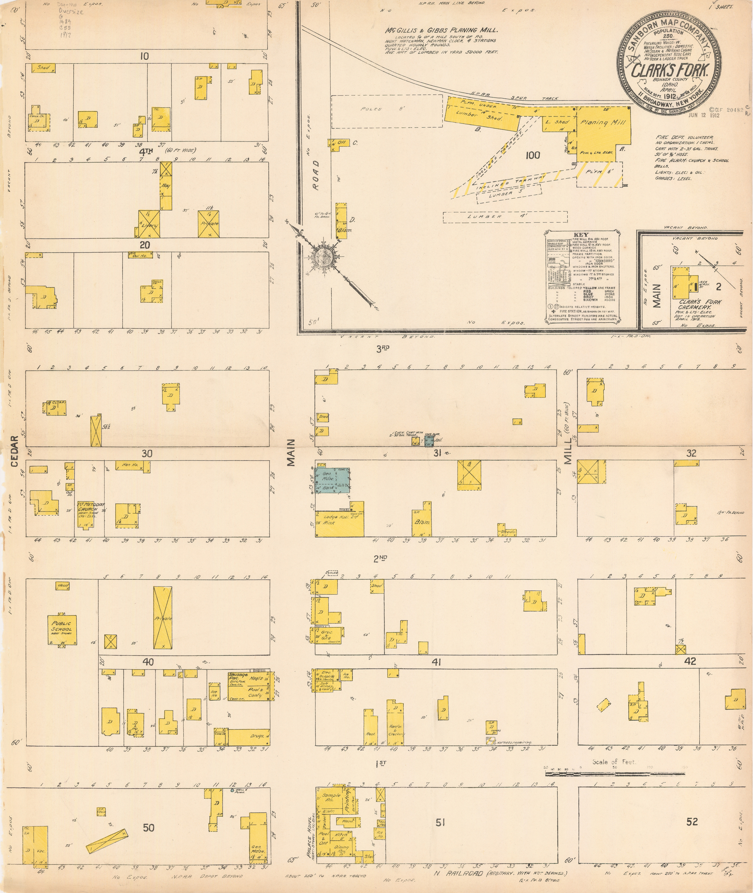
Sanborn Map of Clark's Fork, Bonner County, Idaho, 1912
- Creator:
-
Sanborn Map Company
- Date Created (ISO Standard):
-
1912-04
- Description:
-
map page highlighting detailed information about the location's features
- Subjects:
-
dwelling
shed
livery
hay
out house
hen house
methodist church
public school
drugs
meat
sausage facility
pool
ice house
general merchandise
hotel
office
kitchen
barber
printing
hardware and crockery
restaurant
electric supplies
soft drinks
grocery
lodging
jail
office
lumber shed
planing mill
creamery
- City:
-
Clark's Fork
- County:
-
Bonner
- Latitude:
-
48.145147
- Longitude:
-
-116.179177
- Type:
-
Image;StillImage
- Format:
-
image/jpeg
Source
- Preferred Citation:
- "Sanborn Map of Clark's Fork, Bonner County, Idaho, 1912", Idaho Sanborn Maps, University of Idaho Library Digital Collections, https://www.lib.uidaho.edu/digital/sanborn/items/sanborn-clarksfork-1912-001.html
Rights
- Rights:
- No Copyright. Material made available by source. For more information, please contact University of Idaho Library Special Collections and Archives Department at libspec@uidaho.edu.
- Standardized Rights:
- https://creativecommons.org/publicdomain/mark/1.0/

- Title:
- Sanborn Map of Clark's Fork, Bonner County, Idaho, 1912
- Creator:
- Sanborn Map Company
- Date Created (ISO Standard):
- 1912-04
- Description:
- map page highlighting detailed information about the location's features
- Subjects:
- dwelling shed livery hay out house hen house methodist church public school drugs meat sausage facility pool ice house general merchandise hotel office kitchen barber printing hardware and crockery restaurant electric supplies soft drinks grocery lodging jail office lumber shed planing mill creamery
- City:
- Clark's Fork
- County:
- Bonner
- Latitude:
- 48.145147
- Longitude:
- -116.179177
- Type:
- Image;StillImage
- Format:
- image/jpeg
Source
- Preferred Citation:
- "Sanborn Map of Clark's Fork, Bonner County, Idaho, 1912", Idaho Sanborn Maps, University of Idaho Library Digital Collections, https://www.lib.uidaho.edu/digital/sanborn/items/sanborn-clarksfork-1912-001.html
Rights
- Rights:
- No Copyright. Material made available by source. For more information, please contact University of Idaho Library Special Collections and Archives Department at libspec@uidaho.edu.
- Standardized Rights:
- https://creativecommons.org/publicdomain/mark/1.0/