
Laclede, Bonner County, 1921
Sanborn Map of Laclede, Bonner County, Idaho, 1921
-
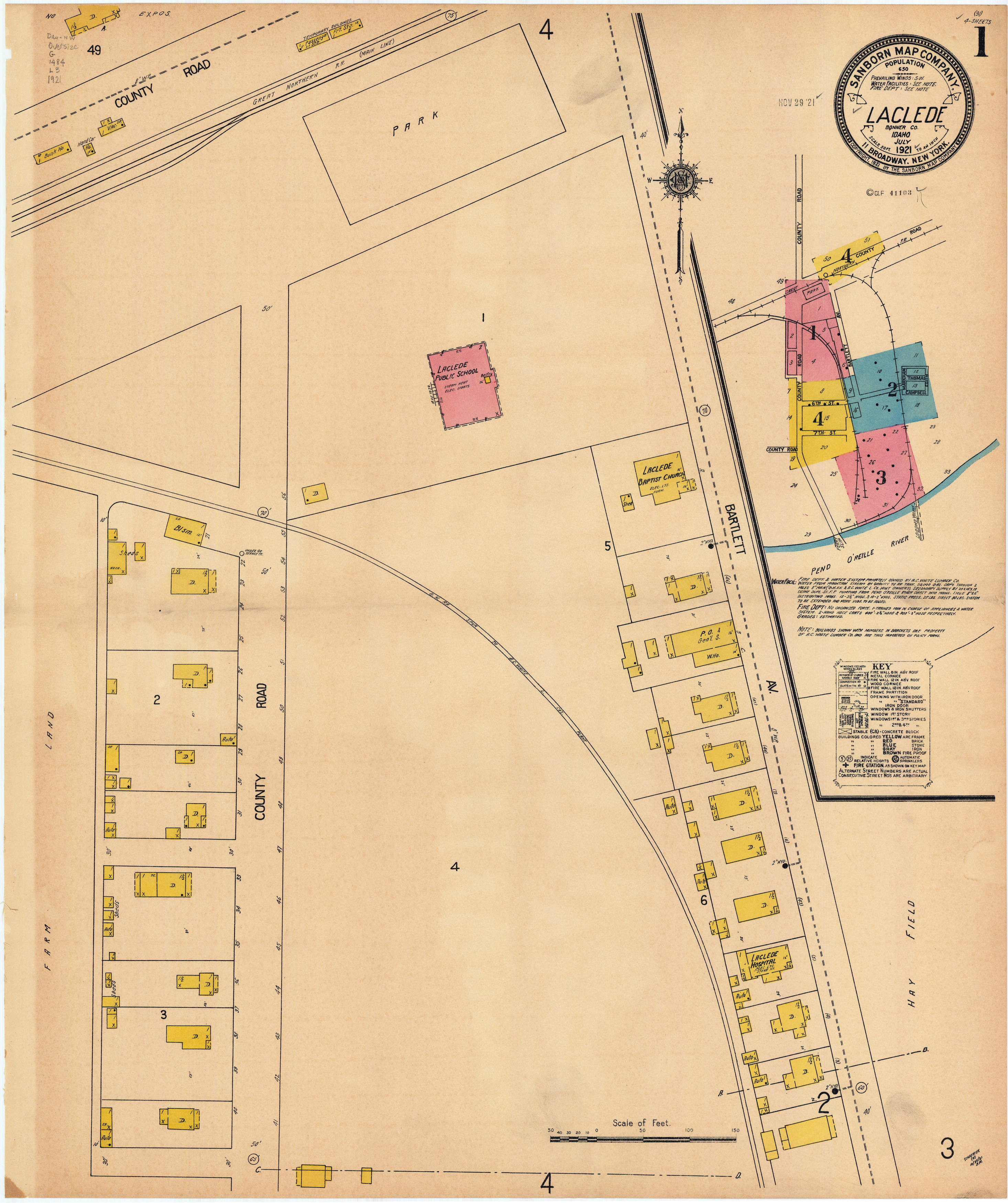
Item 1 of 4
- Title:
- Sanborn Map of Laclede, Bonner County, Idaho, 1921
- Creator:
- Sanborn Map Company
- Date Created (ISO Standard):
- 1921-07
- Description:
- map page highlighting detailed information about the location's features
- Subjects:
- dwelling bunk house black smith shed public school auto baptist church post office and general store ware house hospital
- City:
- Laclede
- County:
- Bonner
- Latitude:
- 48.168606
- Longitude:
- -116.755939
- Type:
- Image;StillImage
- Format:
- image/jpeg
Source
- Preferred Citation:
- "Sanborn Map of Laclede, Bonner County, Idaho, 1921", Idaho Sanborn Maps, University of Idaho Library Digital Collections
- Reference Link:
- https://www.lib.uidaho.edu/digital/sanborn/items/laclede-1921.html#sanborn-laclede-1921-001
Rights
- Rights:
- No Copyright. Material made available by source. For more information, please contact University of Idaho Library Special Collections and Archives Department at libspec@uidaho.edu.
- Standardized Rights:
- https://creativecommons.org/publicdomain/mark/1.0/
Sanborn Map of Laclede, Bonner County, Idaho, 1921
-
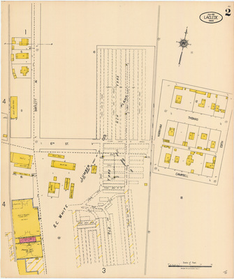
Item 2 of 4
- Title:
- Sanborn Map of Laclede, Bonner County, Idaho, 1921
- Creator:
- Sanborn Map Company
- Date Created (ISO Standard):
- 1921-07
- Description:
- map page highlighting detailed information about the location's features
- Subjects:
- dwelling general merchandise ware house auto general store general office wood shed bunk house boarding laundry store house ice house planing mill lumber yard
- City:
- Laclede
- County:
- Bonner
- Latitude:
- 48.164264
- Longitude:
- -116.755959
- Type:
- Image;StillImage
- Format:
- image/jpeg
Source
- Preferred Citation:
- "Sanborn Map of Laclede, Bonner County, Idaho, 1921", Idaho Sanborn Maps, University of Idaho Library Digital Collections
- Reference Link:
- https://www.lib.uidaho.edu/digital/sanborn/items/laclede-1921.html#sanborn-laclede-1921-002
Rights
- Rights:
- No Copyright. Material made available by source. For more information, please contact University of Idaho Library Special Collections and Archives Department at libspec@uidaho.edu.
- Standardized Rights:
- https://creativecommons.org/publicdomain/mark/1.0/
Sanborn Map of Laclede, Bonner County, Idaho, 1921
-
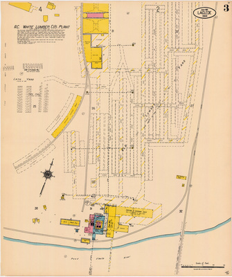
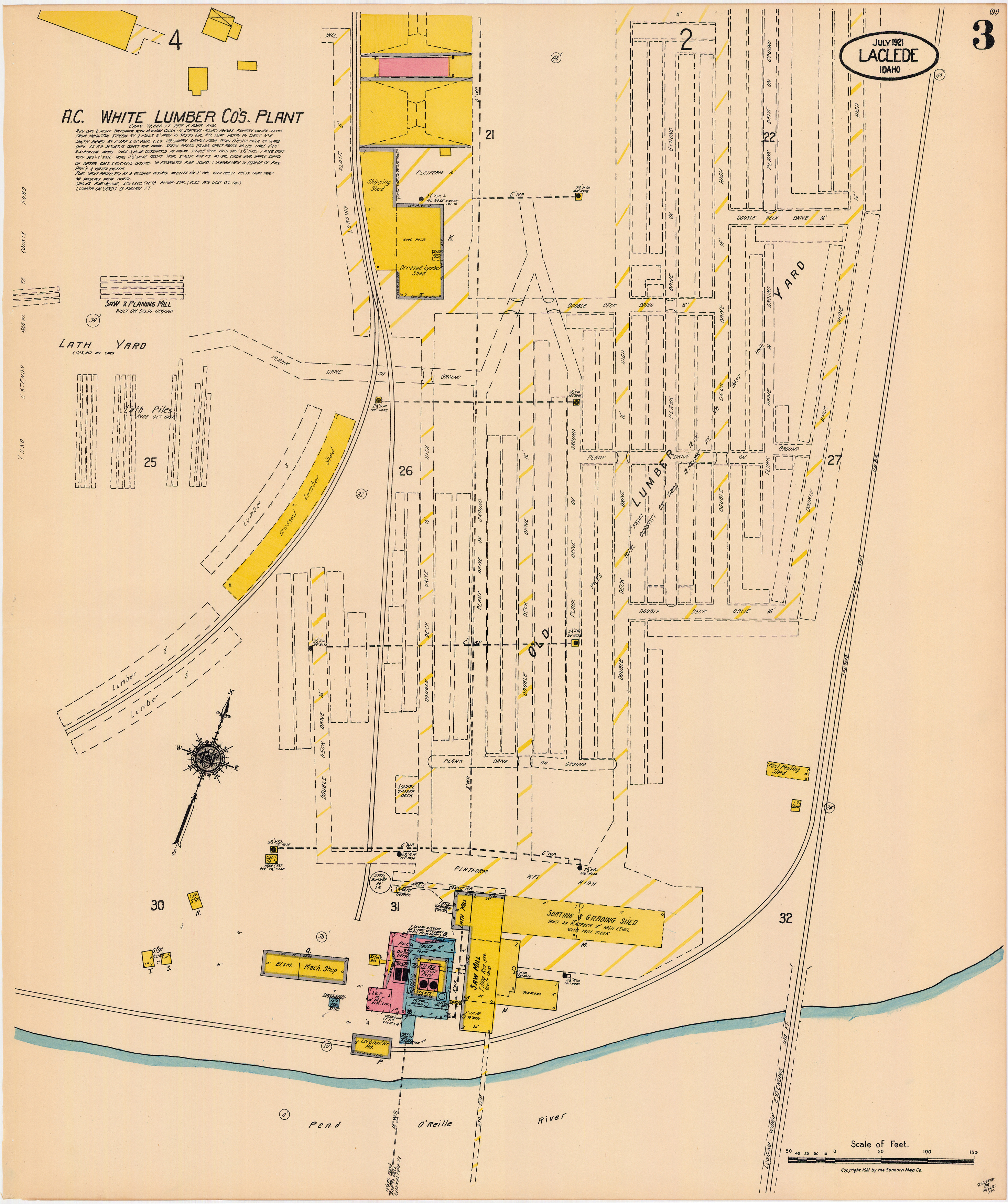
Item 3 of 4
- Title:
- Sanborn Map of Laclede, Bonner County, Idaho, 1921
- Creator:
- Sanborn Map Company
- Date Created (ISO Standard):
- 1921-07
- Description:
- map page highlighting detailed information about the location's features
- Subjects:
- shipping shed dressed lumber shed black smith machine shop locomotive house refuse bin fuel vault dutch oven saw mill shed lumber yard sorting and grading shed saw and planing mill
- City:
- Laclede
- County:
- Bonner
- Latitude:
- 48.163355
- Longitude:
- -116.752815
- Type:
- Image;StillImage
- Format:
- image/jpeg
Source
- Preferred Citation:
- "Sanborn Map of Laclede, Bonner County, Idaho, 1921", Idaho Sanborn Maps, University of Idaho Library Digital Collections
- Reference Link:
- https://www.lib.uidaho.edu/digital/sanborn/items/laclede-1921.html#sanborn-laclede-1921-003
Rights
- Rights:
- No Copyright. Material made available by source. For more information, please contact University of Idaho Library Special Collections and Archives Department at libspec@uidaho.edu.
- Standardized Rights:
- https://creativecommons.org/publicdomain/mark/1.0/
Sanborn Map of Laclede, Bonner County, Idaho, 1921
-
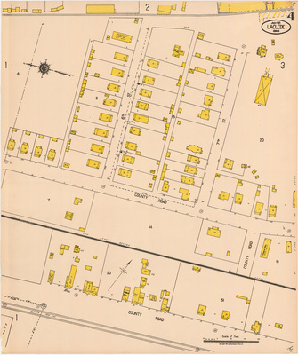
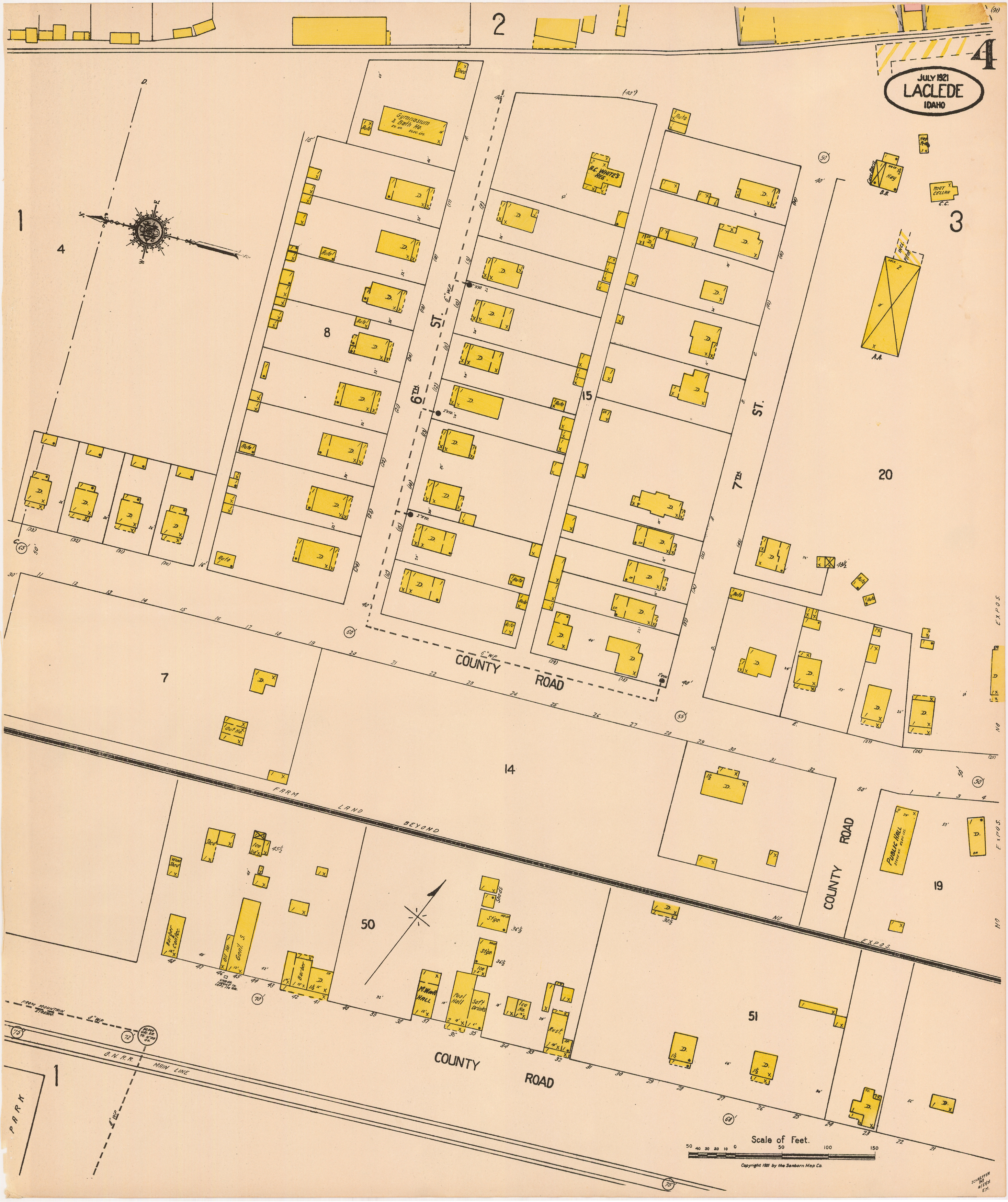
Item 4 of 4
- Title:
- Sanborn Map of Laclede, Bonner County, Idaho, 1921
- Creator:
- Sanborn Map Company
- Date Created (ISO Standard):
- 1921-07
- Description:
- map page highlighting detailed information about the location's features
- Subjects:
- dwelling auto gymnasium and bath house hay root cellar public hall restaurant ice house soft drinks pool hall barber general store oil house barber and confectionary out house sood shed storage
- City:
- Laclede
- County:
- Bonner
- Latitude:
- 48.164106
- Longitude:
- -116.757214
- Type:
- Image;StillImage
- Format:
- image/jpeg
Source
- Preferred Citation:
- "Sanborn Map of Laclede, Bonner County, Idaho, 1921", Idaho Sanborn Maps, University of Idaho Library Digital Collections
- Reference Link:
- https://www.lib.uidaho.edu/digital/sanborn/items/laclede-1921.html#sanborn-laclede-1921-004
Rights
- Rights:
- No Copyright. Material made available by source. For more information, please contact University of Idaho Library Special Collections and Archives Department at libspec@uidaho.edu.
- Standardized Rights:
- https://creativecommons.org/publicdomain/mark/1.0/
- Title:
- Sanborn Map of Laclede, Bonner County, Idaho, 1921
- Creator:
- Sanborn Map Company
- Date Created (ISO Standard):
- 1921-07
- Description:
- group of map pages highlighting detailed information about the location's features
- City:
- Laclede
- County:
- Bonner
- Latitude:
- 48.16963639
- Longitude:
- -116.7545886
- Type:
- Image;StillImage
- Format:
- record
Source
- Preferred Citation:
- "Sanborn Map of Laclede, Bonner County, Idaho, 1921", Idaho Sanborn Maps, University of Idaho Library Digital Collections, https://www.lib.uidaho.edu/digital/sanborn/items/laclede-1921.html
Rights
- Rights:
- No Copyright. Material made available by source. For more information, please contact University of Idaho Library Special Collections and Archives Department at libspec@uidaho.edu.
- Standardized Rights:
- https://creativecommons.org/publicdomain/mark/1.0/