Coeur D'Alene, Kootenai County, 1896
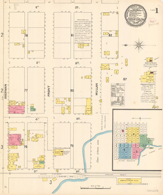 View Map
Sanborn Map of Coeur D'Alene, Kootenai County, Idaho, 1896
-
Item 1 of 4
- Title:
-
Sanborn Map of Coeur D'Alene, Kootenai County, Idaho, 1896
- Creator:
-
Sanborn Map Company
- Date Created (ISO Standard):
-
1896-04
- Description:
-
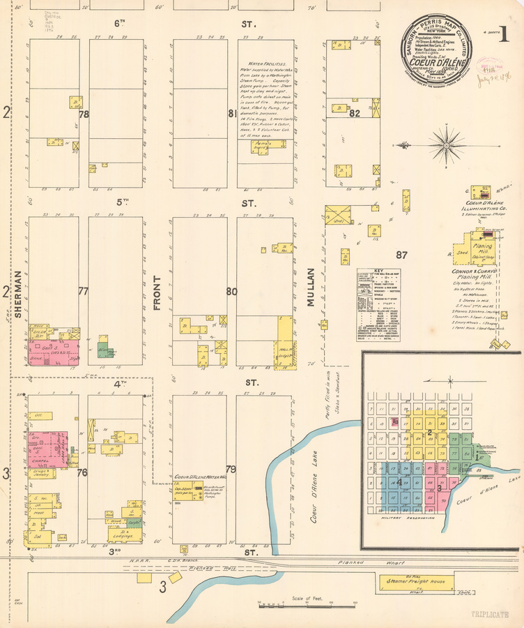
map page highlighting detailed information about the location's features
- Subjects:
-
dwelling
cabin
general store
bank
office
wagon shop
carpenter
lodging
water works
saloon
meat
chapel
grocery
out house
drugs and jewelry
female boarding
planing mill
shed
steamer freight house
- City:
-
Coeur D'Alene
- County:
-
Kootenai
- Latitude:
-
47.672875
- Longitude:
-
-116.781144
- Type:
-
Image;StillImage
- Format:
-
image/jpeg
Source
- Preferred Citation:
- "Sanborn Map of Coeur D'Alene, Kootenai County, Idaho, 1896", Idaho Sanborn Maps, University of Idaho Library Digital Collections
- Reference Link:
- https://www.lib.uidaho.edu/digital/sanborn/items/coeurdalene-1896.html#sanborn-coeurdalene-1896-001
Rights
- Rights:
- No Copyright. Material made available by source. For more information, please contact University of Idaho Library Special Collections and Archives Department at libspec@uidaho.edu.
- Standardized Rights:
- https://creativecommons.org/publicdomain/mark/1.0/
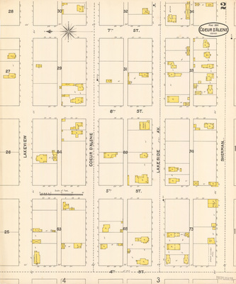 View Map
Sanborn Map of Coeur D'Alene, Kootenai County, Idaho, 1896
-
Item 2 of 4
- Title:
-
Sanborn Map of Coeur D'Alene, Kootenai County, Idaho, 1896
- Creator:
-
Sanborn Map Company
- Date Created (ISO Standard):
-
1896-05
- Description:
-
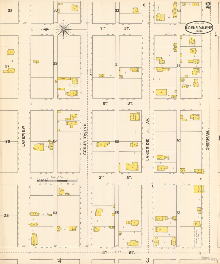
map page highlighting detailed information about the location's features
- Subjects:
-
Dwelling
presbyterian church
small lumber piles
church
ruin of fire
lumber yard
detached dwellings
hotel
general merchandise
saloon
storage
livery
feed
dwelling
cobbler
meat
hardware
cellar
shed
masonic hall
cabin
chinese dwellings
wash house
warehouse
barber
telegraph office
office
restaurant
kitchen
bank
Post office
stationary
whole
liquors
jewelry
printing
Public School
General Store
Hand Printing
Storage
Dwelling
Drugs
Hotel
Dining Room
Methodist Church
Church
- City:
-
Coeur D'Alene
- County:
-
Kootenai
- Latitude:
-
47.674693,
- Longitude:
-
-116.77895
- Type:
-
Image;StillImage
- Format:
-
image/jpeg
Source
- Preferred Citation:
- "Sanborn Map of Coeur D'Alene, Kootenai County, Idaho, 1896", Idaho Sanborn Maps, University of Idaho Library Digital Collections
- Reference Link:
- https://www.lib.uidaho.edu/digital/sanborn/items/coeurdalene-1896.html#sanborn-coeurdalene-1896-002
Rights
- Rights:
- No Copyright. Material made available by source. For more information, please contact University of Idaho Library Special Collections and Archives Department at libspec@uidaho.edu.
- Standardized Rights:
- https://creativecommons.org/publicdomain/mark/1.0/
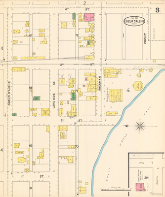 View Map
Sanborn Map of Coeur D'Alene, Kootenai County, Idaho, 1896
-
Item 3 of 4
- Title:
-
Sanborn Map of Coeur D'Alene, Kootenai County, Idaho, 1896
- Creator:
-
Sanborn Map Company
- Date Created (ISO Standard):
-
1896-04
- Description:
-
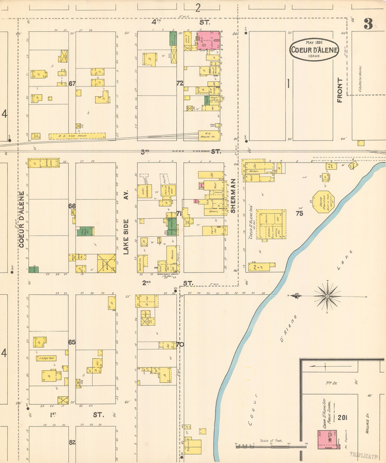
map page highlighting detailed information about the location's features
- Subjects:
-
dwelling
tool house
coal
railroad depot
painting
chinese wash house
cabin
livery
lodge hall
office
saloon
ice house
chinese
laundry
bakery
restaurant
cobbler
railroad roundhouse
repair
drugs
notions
furniture and undertaker
general store
hay
printing
barber
kitchen
post office
dance pavilion
public school
- City:
-
Coeur D'Alene
- County:
-
Kootenai
- Latitude:
-
47.673534
- Longitude:
-
-116.784118
- Type:
-
Image;StillImage
- Format:
-
image/jpeg
Source
- Preferred Citation:
- "Sanborn Map of Coeur D'Alene, Kootenai County, Idaho, 1896", Idaho Sanborn Maps, University of Idaho Library Digital Collections
- Reference Link:
- https://www.lib.uidaho.edu/digital/sanborn/items/coeurdalene-1896.html#sanborn-coeurdalene-1896-003
Rights
- Rights:
- No Copyright. Material made available by source. For more information, please contact University of Idaho Library Special Collections and Archives Department at libspec@uidaho.edu.
- Standardized Rights:
- https://creativecommons.org/publicdomain/mark/1.0/
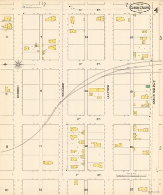 View Map
Sanborn Map of Coeur D'Alene, Kootenai County, Idaho, 1896
-
Item 4 of 4
- Title:
-
Sanborn Map of Coeur D'Alene, Kootenai County, Idaho, 1896
- Creator:
-
Sanborn Map Company
- Date Created (ISO Standard):
-
1896-04
- Description:
-
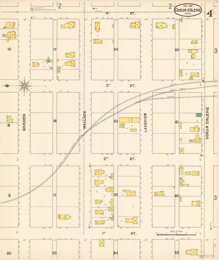
map page highlighting detailed information about the location's features
- Subjects:
-
dwelling
hose cart
shed
hen house
hay
warehouse
creamery
- City:
-
Coeur D'Alene
- County:
-
Kootenai
- Latitude:
-
47.677432
- Longitude:
-
-116.783243
- Type:
-
Image;StillImage
- Format:
-
image/jpeg
Source
- Preferred Citation:
- "Sanborn Map of Coeur D'Alene, Kootenai County, Idaho, 1896", Idaho Sanborn Maps, University of Idaho Library Digital Collections
- Reference Link:
- https://www.lib.uidaho.edu/digital/sanborn/items/coeurdalene-1896.html#sanborn-coeurdalene-1896-004
Rights
- Rights:
- No Copyright. Material made available by source. For more information, please contact University of Idaho Library Special Collections and Archives Department at libspec@uidaho.edu.
- Standardized Rights:
- https://creativecommons.org/publicdomain/mark/1.0/
- Title:
-
Sanborn Map of Coeur D'Alene, Kootenai County, Idaho, 1896
- Creator:
-
Sanborn Map Company
- Date Created (ISO Standard):
-
1896-04
- Description:
-
group of map pages highlighting detailed information about the location's features
- City:
-
Coeur D'Alene
- County:
-
Kootenai
- Latitude:
-
47.67379206
- Longitude:
-
-116.7800812
- Type:
-
Image;StillImage
- Format:
-
record
Source
- Preferred Citation:
- "Sanborn Map of Coeur D'Alene, Kootenai County, Idaho, 1896", Idaho Sanborn Maps, University of Idaho Library Digital Collections, https://www.lib.uidaho.edu/digital/sanborn/items/coeurdalene-1896.html
Rights
- Rights:
- No Copyright. Material made available by source. For more information, please contact University of Idaho Library Special Collections and Archives Department at libspec@uidaho.edu.
- Standardized Rights:
- https://creativecommons.org/publicdomain/mark/1.0/

Sanborn Map of Coeur D'Alene, Kootenai County, Idaho, 1896
-
Item 1 of 4
- Title:
- Sanborn Map of Coeur D'Alene, Kootenai County, Idaho, 1896
- Creator:
- Sanborn Map Company
- Date Created (ISO Standard):
- 1896-04
- Description:
- map page highlighting detailed information about the location's features
- Subjects:
- dwelling cabin general store bank office wagon shop carpenter lodging water works saloon meat chapel grocery out house drugs and jewelry female boarding planing mill shed steamer freight house
- City:
- Coeur D'Alene
- County:
- Kootenai
- Latitude:
- 47.672875
- Longitude:
- -116.781144
- Type:
- Image;StillImage
- Format:
- image/jpeg
Source
- Preferred Citation:
- "Sanborn Map of Coeur D'Alene, Kootenai County, Idaho, 1896", Idaho Sanborn Maps, University of Idaho Library Digital Collections
- Reference Link:
- https://www.lib.uidaho.edu/digital/sanborn/items/coeurdalene-1896.html#sanborn-coeurdalene-1896-001
Rights
- Rights:
- No Copyright. Material made available by source. For more information, please contact University of Idaho Library Special Collections and Archives Department at libspec@uidaho.edu.
- Standardized Rights:
- https://creativecommons.org/publicdomain/mark/1.0/

Sanborn Map of Coeur D'Alene, Kootenai County, Idaho, 1896
-
Item 2 of 4
- Title:
- Sanborn Map of Coeur D'Alene, Kootenai County, Idaho, 1896
- Creator:
- Sanborn Map Company
- Date Created (ISO Standard):
- 1896-05
- Description:
- map page highlighting detailed information about the location's features
- Subjects:
- Dwelling presbyterian church small lumber piles church ruin of fire lumber yard detached dwellings hotel general merchandise saloon storage livery feed dwelling cobbler meat hardware cellar shed masonic hall cabin chinese dwellings wash house warehouse barber telegraph office office restaurant kitchen bank Post office stationary whole liquors jewelry printing Public School General Store Hand Printing Storage Dwelling Drugs Hotel Dining Room Methodist Church Church
- City:
- Coeur D'Alene
- County:
- Kootenai
- Latitude:
- 47.674693,
- Longitude:
- -116.77895
- Type:
- Image;StillImage
- Format:
- image/jpeg
Source
- Preferred Citation:
- "Sanborn Map of Coeur D'Alene, Kootenai County, Idaho, 1896", Idaho Sanborn Maps, University of Idaho Library Digital Collections
- Reference Link:
- https://www.lib.uidaho.edu/digital/sanborn/items/coeurdalene-1896.html#sanborn-coeurdalene-1896-002
Rights
- Rights:
- No Copyright. Material made available by source. For more information, please contact University of Idaho Library Special Collections and Archives Department at libspec@uidaho.edu.
- Standardized Rights:
- https://creativecommons.org/publicdomain/mark/1.0/

Sanborn Map of Coeur D'Alene, Kootenai County, Idaho, 1896
-
Item 3 of 4
- Title:
- Sanborn Map of Coeur D'Alene, Kootenai County, Idaho, 1896
- Creator:
- Sanborn Map Company
- Date Created (ISO Standard):
- 1896-04
- Description:
- map page highlighting detailed information about the location's features
- Subjects:
- dwelling tool house coal railroad depot painting chinese wash house cabin livery lodge hall office saloon ice house chinese laundry bakery restaurant cobbler railroad roundhouse repair drugs notions furniture and undertaker general store hay printing barber kitchen post office dance pavilion public school
- City:
- Coeur D'Alene
- County:
- Kootenai
- Latitude:
- 47.673534
- Longitude:
- -116.784118
- Type:
- Image;StillImage
- Format:
- image/jpeg
Source
- Preferred Citation:
- "Sanborn Map of Coeur D'Alene, Kootenai County, Idaho, 1896", Idaho Sanborn Maps, University of Idaho Library Digital Collections
- Reference Link:
- https://www.lib.uidaho.edu/digital/sanborn/items/coeurdalene-1896.html#sanborn-coeurdalene-1896-003
Rights
- Rights:
- No Copyright. Material made available by source. For more information, please contact University of Idaho Library Special Collections and Archives Department at libspec@uidaho.edu.
- Standardized Rights:
- https://creativecommons.org/publicdomain/mark/1.0/

Sanborn Map of Coeur D'Alene, Kootenai County, Idaho, 1896
-
Item 4 of 4
- Title:
- Sanborn Map of Coeur D'Alene, Kootenai County, Idaho, 1896
- Creator:
- Sanborn Map Company
- Date Created (ISO Standard):
- 1896-04
- Description:
- map page highlighting detailed information about the location's features
- Subjects:
- dwelling hose cart shed hen house hay warehouse creamery
- City:
- Coeur D'Alene
- County:
- Kootenai
- Latitude:
- 47.677432
- Longitude:
- -116.783243
- Type:
- Image;StillImage
- Format:
- image/jpeg
Source
- Preferred Citation:
- "Sanborn Map of Coeur D'Alene, Kootenai County, Idaho, 1896", Idaho Sanborn Maps, University of Idaho Library Digital Collections
- Reference Link:
- https://www.lib.uidaho.edu/digital/sanborn/items/coeurdalene-1896.html#sanborn-coeurdalene-1896-004
Rights
- Rights:
- No Copyright. Material made available by source. For more information, please contact University of Idaho Library Special Collections and Archives Department at libspec@uidaho.edu.
- Standardized Rights:
- https://creativecommons.org/publicdomain/mark/1.0/
- Title:
- Sanborn Map of Coeur D'Alene, Kootenai County, Idaho, 1896
- Creator:
- Sanborn Map Company
- Date Created (ISO Standard):
- 1896-04
- Description:
- group of map pages highlighting detailed information about the location's features
- City:
- Coeur D'Alene
- County:
- Kootenai
- Latitude:
- 47.67379206
- Longitude:
- -116.7800812
- Type:
- Image;StillImage
- Format:
- record
Source
- Preferred Citation:
- "Sanborn Map of Coeur D'Alene, Kootenai County, Idaho, 1896", Idaho Sanborn Maps, University of Idaho Library Digital Collections, https://www.lib.uidaho.edu/digital/sanborn/items/coeurdalene-1896.html
Rights
- Rights:
- No Copyright. Material made available by source. For more information, please contact University of Idaho Library Special Collections and Archives Department at libspec@uidaho.edu.
- Standardized Rights:
- https://creativecommons.org/publicdomain/mark/1.0/

